


Russian Federation
Russian Federation
VAK Russia 1.6
UDC 551.243.8
UDC 551.243.1
UDC 551.243.6
UDC 55
UDC 550.34
UDC 550.383
CSCSTI 38.21
CSCSTI 38.17
CSCSTI 37.01
CSCSTI 37.15
CSCSTI 37.25
CSCSTI 37.31
CSCSTI 38.01
CSCSTI 36.00
CSCSTI 37.00
CSCSTI 38.00
CSCSTI 39.00
CSCSTI 52.00
Russian Classification of Professions by Education 05.00.00
Russian Library and Bibliographic Classification 26
Russian Trade and Bibliographic Classification 63
BISAC SCI SCIENCE
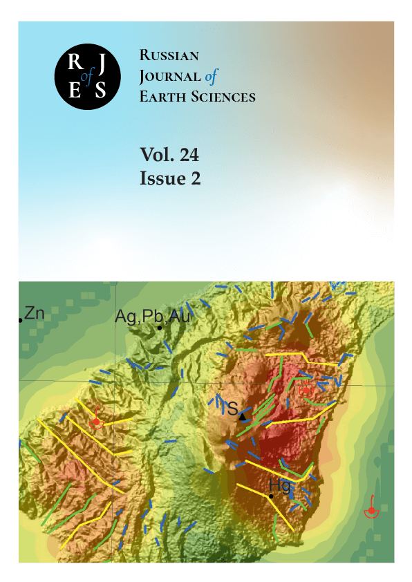
The paper is devoted to the study of the faults on Kunashir Island, focusing on their classification, morphology, kinematics, timing, and causes of formation, which are key to understanding the tectonic evolution of the area. The magma-supporting role of these faults is noted, contributing to the understanding of the distribution of volcanic and plutonic formations in the Great Kuril Ridge. The ore-controlling role of the faults was evaluated, which may contribute to the discovery of new mineral deposits. Additionally, studying these faults is important for improving the prediction of earthquakes and tsunamis. The research methodology includes an integrated approach that combines traditional geological observations with modern remote sensing methods, allowing us to detail the map of the Kunashir Island rupture faults. The results of the work confirm the presence of three systems of tectonic structures that differ in depth of emplacement, length, timing, kinematics, and causes of formation. The study contributes to our understanding of the complex geological structure of Kunashir Island and the entire island arc and provides a basis for further research in this area.
Kuril Island Arc, Kunashir, lineament analysis, remote sensing data, strike-slip faults, shear, back-arc basin, Kuril Basin
1. Ageev A. S., Egorov A. S. Features of the deep structure of the Baikal-Stanovoy regional shear zones on geological, geophysical and distantional data in the profile 3-DV (southern section) // Regional Geology and Metallogeny. — 2017. — No. 70. — P. 36–40.
2. Avdeiko G. P., Palueva A. A., Khleborodova O. A. Geodynamic conditions of volcanism and magma formation in the Kurile-Kamchatka island-arc system // Petrology. — 2006. — Vol. 14, no. 3. — P. 230–246. — DOI:https://doi.org/10.1134/S0869591106030027.
3. Avdeiko G. P., Popruzhenko S. V., Palueva A. A. Modern structure of the Kurile-Kamchatka region and magma-forming conditions // Geodynamics and volcanism of the Kurile-Kamchatka Island-Arc system. — Petropavlovsk-Kamchatsky : IVGiG FEB RAS, 2001. — P. 9–33.
4. Baranov B. V., Werner R., Hoernle K. A., et al. Evidence for compressionally induced high subsidence rates in the Kurile Basin (Okhotsk Sea) // Tectonophysics. — 2002. — Vol. 350, no. 1. — P. 63–97. — DOI:https://doi.org/10.1016/S0040- 1951(02)00081-1.
5. Bergal-Kuvikas O. V. Volumes of quaternary volcanic material of the Kuril Island Arc: analysis of spatial variations in correlation with subduction zone // Tikhookeanskaya Geologiya. — 2015. — Vol. 34, no. 2. — P. 103–116.
6. Bergal-Kuvikas O. V., Buslov M. M., Bushenkova N. A., et al. Transition from the Continental Margin of Kamchatka to the Island Arc of the Kurile Islands: Features of Volcanism, Crustal Deformation and Geophysical Parameters of the Slab // Russian Geology and Geophysics. — 2023. — Vol. 64, no. 10. — P. 1227–1240. — DOI:https://doi.org/10.2113/RGG20234558.
7. Beygi S., Tadayon M., Ilalova R. K., et al. Petrochemical and Structural Characteristics of Porphyry Copper Mineralization in the Astaneh Ore Deposit, Middle Part of the Urumieh-Dokhtar Magmatic Arc (Iran) // Geodynamics & Tectonophysics. — 2023. — Vol. 14, no. 2. — DOI:https://doi.org/10.5800/GT-2023-14-2-0691.
8. Bolshakova N. V., Fedorova K. S. The Possibilities of Using a Qualitative Interpretation of The Potential for Creating a Zonal-Block Model of The Northern Flank of The Okhotsk Sea Region // Engineering and Mining Geophysics 2021. — European Association of Geoscientists & Engineers, 2021. — DOI:https://doi.org/10.3997/2214-4609.202152157.
9. De Grave J., Zhimulev F. I., Glorie S., et al. Late Palaeogene emplacement and late Neogene-Quaternary exhumation of the Kuril island-arc root (Kunashir island) constrained by multi-method thermochronometry // Geoscience Frontiers. — 2016. — Vol. 7, no. 2. — P. 211–220. — DOI:https://doi.org/10.1016/j.gsf.2015.05.002.
10. Gulbin, Yu. L., Akbarpuran Khaiyati S. A., Sirotkin A. N. Mineral composition and thermobarometry of metamorphic rocks of western Ny Friesland, Svalbard // Journal of Mining Institute. — 2023. — Vol. 263. — P. 657–673.
11. Kalinin D. F., Egorov A. S., Bolshakova N. V. Oil and Gas Potential of the West Kamchatka Coast and its Relation to the Structural and Tectonic Structure of the Sea of Okhotsk Region Based on Geophysical Data // Bulletin of Kamchatka Regional Association «Educational-Scientific Center». Earth Sciences. — 2022. — Vol. 1, no. 53. — P. 59–75. — DOI:https://doi.org/10.31431/1816-5524-2022-1-53-59-75.
12. Kalinin D. F., Egorov A. S., Bolshakova N. V., et al. Information and Statistical Forecast of Oil and Gas Potential in the Marginal Part of the Koryak-Kamchatka Folded Region // Bulletin of Kamchatka Regional Association «Educational-Scientific Center». Earth Sciences. — 2023. — Vol. 57, no. 1. — P. 63–88. — DOI:https://doi.org/10.31431/1816-5524-2023-1-57-63-88.
13. Khubaeva O. R., Bergal-Kuvikas O. V., Sidorov M. D. Identification of Ruptures and Their Interaction with Hydrothermal Magmatic Systems at the Northern Part of Paramushir Isl. (Kuril Islands, Russia): 3D Modeling of Crustal Fragmentation // Geotectonics. — 2020. — No. 6. — P. 77–90. — DOI:https://doi.org/10.31857/S0016853X20060077.
14. Khubaeva O. R., Degterev A. V., Kozlov D. N., et al. Morphology and Specific Features of Formation of Thermal Lake Utinaya Banya (Iturup Island, Southern Kuril Islands) // Russian Geology and Geophysics. — 2023. — Vol. 64, no. 9. — P. 1048–1057. — DOI:https://doi.org/10.2113/RGG20234551.
15. Koroleva T. P., Smirnov I. G. Geological map of the USSR, scale 1:200,000. Kuril series, sheet K-55-II. Explanatory note. — Moscow : Nedra, 1971. — P. 48.
16. Kovtunovich P. Y., Safronov A. D., Udodov V. V., et al. Geological structure and useful minerals of the islands of Iturup, Kunashir and the adjacent water area bottom. Report of the Kamui GSP on the results of geological study at a scale of 1:200,000 and preparation for publication of sheets (L-55-XXII, XXIII, XXVIII, XXIX, XXXII, XXXIII, XXXIV; K-55-II) of the State Geological Map - 200 of the Kuril Series with the implementation of GGS-50 on the area of sheets L-54-104-G, 116-B, carried out in 1987-2000. on Kamuiskaya Square in 4 books. — Yuzhno-Sakhalinsk : Sakhalin TSU, Yuzhno-Sakhalinsk Geological Prospecting Expedition, 2002. — P. 921.
17. Krikun N., Babenko I., Talovina I., et al. Geological Structure and Perspectives of Oil and Gas Bearing in Neogene Sediments of the Southern Part of the Kuril Island Arc System // Russian Journal of Earth Sciences. — 2024. — P. 1–16. — DOI:https://doi.org/10.2205/2024ES000905.
18. Krikun N. S. Application of remote sensing methods to clarify the structural and geological features of the Kuril region (using the example of the islands of Kunashir and Iturup) // International scientific conference of young researchers «The Young - for the Earth Sciences». — Moscow : Russian State Geological Prospecting University named after S. Ordzhonikidze, 2022. — P. 21–24.
19. Krikun N. S. Study of distribution patterns of metallic minerals of Kunashir Island using different types of geological and geophysical data and remote sensing data // Collection of abstracts of reports of the XIII international scientific and practical conference "Scientific and methodological foundations for forecasting, prospecting, and assessing deposits of diamonds, precious and non-ferrous metals" April 10-12, 2024. — Moscow : TsNIGRI, 2024. — P. 195–197.
20. Krikun N. S., Fedorova E. R., Talovina I. V. Database of lineaments of Iturup Island // Certificate of registration of the database No. 2021621173, declared: 05/27/2021, published: 06/01/2021; applicant St. Petersburg State University. - 179 kb. — 2021.
21. Martynov, A. Yu., Martynov Y. A., Rybin A. V., et al. Role of back-arc tectonics in the origin of subduction magmas: new Sr, Nd, and Pb isotope data from Middle Miocene lavas of Kunashir Island (Kurile Island Arc) // Geology and Geophysics. — 2015. — Vol. 56, no. 3. — P. 469–487. — DOI:https://doi.org/10.15372/GiG20150301.
22. Mingaleva T., Gorelik G., Egorov A., et al. Correction of Depth-Velocity Models by Gravity Prospecting for Hard-to-Reach Areas of the Shelf Zone // Mining informational and analytical bulletin. — 2022. — No. 10/1. — P. 77–86. — DOI:https://doi.org/10.25018/0236_1493_2022_101_0_77.
23. Pavlenkova N. I., Kashubin S. N., Gontovaya L. I., et al. Deep structure and geodynamics of the Sea of Okhotsk region // Regional Geology and Metallology. — 2018. — No. 76. — P. 70–82.
24. Piip V. B., Rodnikov A. G. The Sea of Okhotsk crust from deep seismic sounding data // Russian Journal of Earth Sciences. — 2004. — Vol. 6, no. 1. — P. 35–48. — DOI:https://doi.org/10.2205/2003ES000140.
25. Proshkina Z. N., Kulinich R. G., Valitov M. G. Structure, Matter Composition, and Deep Structure of the Oceanic Slope of the Central Kuril Islands: New Evidence // Russian Journal of Pacific Geology. — 2017. — Vol. 36, no. 6. — P. 436–446. — DOI:https://doi.org/10.1134/s1819714017060045.
26. Schellart W. P., Jessell M. W., Lister G. S. Asymmetric deformation in the backarc region of the Kuril arc, northwest Pacific: New insights from analogue modeling // Tectonics. — 2003. — Vol. 22, no. 5. — DOI:https://doi.org/10.1029/2002TC001473.
27. Senchina N., Asoskov A., Gorelik G. Evaluation of Displacements Caused by Strike-Slip Deformations Using Correlation Characteristics Based on Potential Field Data // Russian Journal of Earth Sciences. — 2023. — P. 1–10. — DOI:https://doi.org/10.2205/2023ES000847.
28. Serbin D., Dmitriev A. Experimental research on the thermal method of drilling by melting the well in ice mass with simultaneous controlled expansion of its diameter // Journal of Mining Institute. — 2022. — Vol. 257. — P. 833–842. — DOI:https://doi.org/10.31897/PMI.2022.82.
29. Sergeev K. F. Tectonics of the Kuril Island System. — Moscow : Nauka, 1976. — P. 239.
30. State Geological Map of the Russian Federation, scale 1:200,000; Second edition. Kuril Series. Sheets L-55-XXII, XXVIII, XXXIV (Kurilsk), L-55-XXIII, XXIX (Reydovo), L-55-XXXIII (Tyatya volcano), K-55-II, 55-XXXII (YuzhnoKurilsk) / ed. by V. K. Rotman. — St. Petersburg : Saint Petersburg Cartographic Factory VSEGEI, 2002. — P. 298.
31. Streltsov M. I. Dislocations of the southern part of the Kuril island arc. — Moscow : Nauka, 1976. — P. 132.
32. Talovina I., Krikun N., Yurchenko Y., et al. Remote sensing techniques in the study of structural and geotectonic features of Iturup Island (the Kuril Islands) // Journal of Mining Institute. — 2022. — DOI:https://doi.org/10.31897/PMI.2022.45.
